

Indiana has seen several rounds of severe weather, and many are likely ready for a break.
Indiana has seen several rounds of severe weather, and many are likely ready for a break.
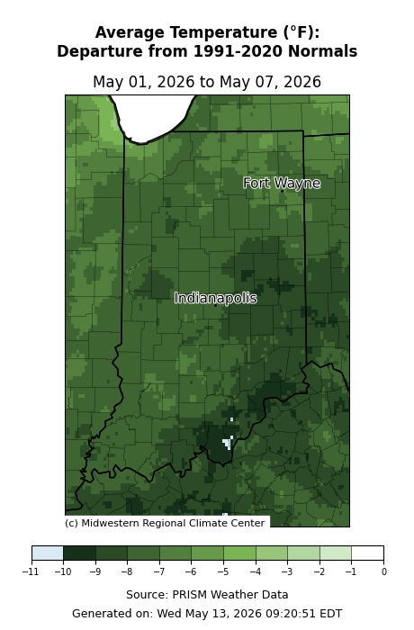
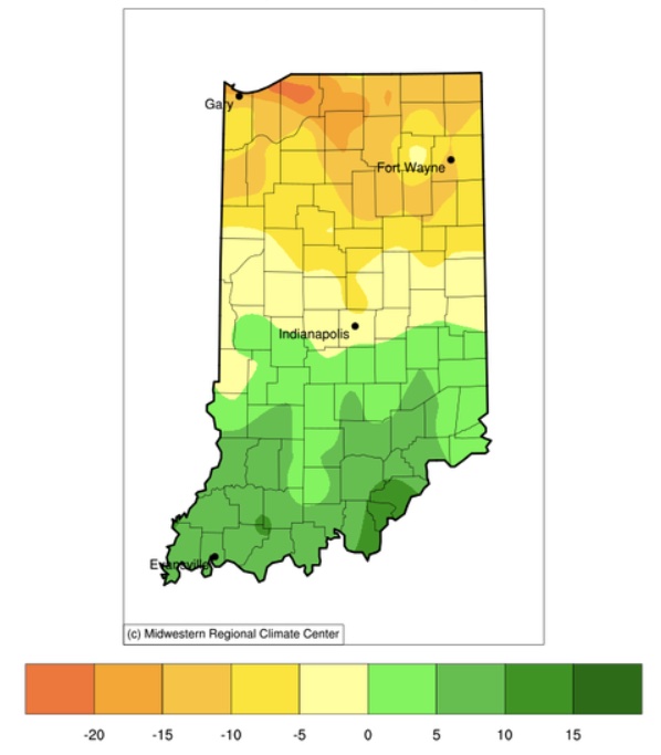
The first week of May certainly didn’t feel like May as temperatures ended up 5-10 deg F below normal across the state (Figure 1).
Temperatures dipped below freezing earlier this week as spring perennials started forcing their way out of their winter slumber.
Precipitation over the last 30 days has been very spotty, the usual narrative when dealing with summertime convection.

One heat wave down, more to come.

Welcome to the start of Hurricane Season that runs from June through November each year.
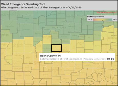
Midwestern farmers have faced a buildup of pesticide resistance in pigweeds (waterhemp and Palmer amaranth), highlighting the importance of scouting to detect weeds early in their growth stages.
What do you think of when you hear the word climate? I would guess answers would range from ‘average weather conditions’ to ‘hot, muggy summers’ to ‘climate change’ to ‘environmental policies and politics’. What a range! Fields of climate can vary from paleoclimate studies (e.g., ice cores and tree rings), to applied climate science (e.g., architectural design and vector-borne diseases like West Nile Virus and Malaria), to climate modeling (e.g., lots of physical equations and computers), to climate change (e.g., ‘but the polar bears, Daddy!’), to climate services (e.g., data translated into information). Among all this diversity, the common thread is the consideration and correlations of what has occurred in our atmosphere historically to better understand and prepare for current and future decisions. Since the late 1800s, our country has had an organized effort to collect observational data (e.g., temperature and precipitation) at hundreds of locations so we can monitor[Read More…]
Indiana has had its fair share of very cold temperatures this winter.
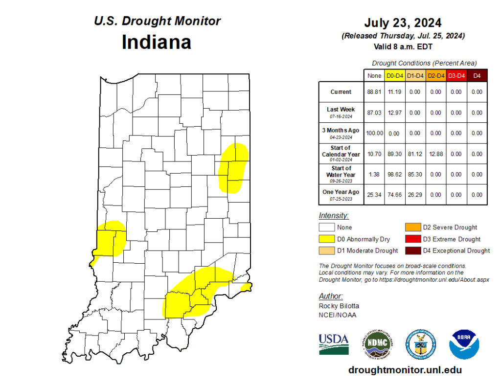
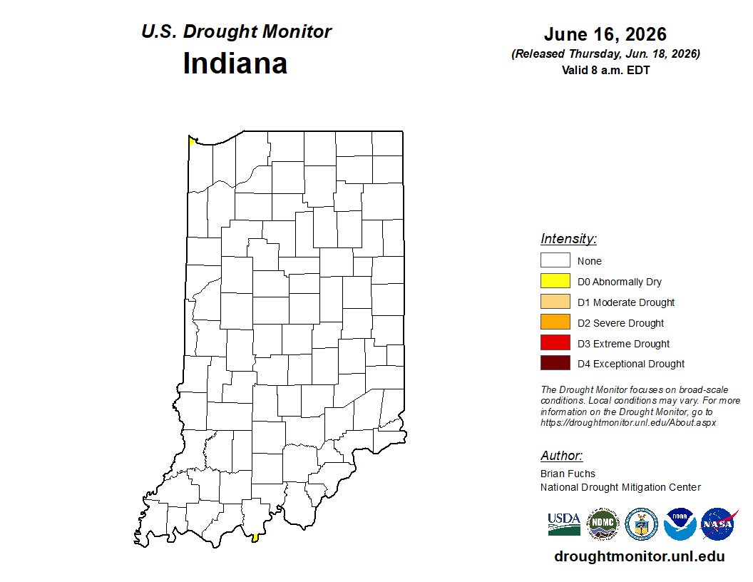
Several weeks ago, Indiana received enough rain to eliminate drought across the state, leaving behind just a few counties in Abnormally Dry (D0) status. Fortunately, this week has been relatively quiet, allowing many areas to alleviate flooding issues. The U.S. Drought Monitor kept those Abnormally Dry areas nearly the same this week (Figure 1), so how might things change? Will this recent dry period re-introduce Moderate Drought (D1) and/or expand those Abnormally Dry areas? Or will more rain keep Indiana in a more normal situation where precipitation passes through every few days, separated by typical Midwest hot and humid conditions? First, it is important to review what has been happening across our state. Over the past two weeks, Figure 2 shows that most of Indiana has receive above-normal precipitation except for southeastern and southern Indiana. However, even those locations are within one inch of normal amounts (based on the 1991-2020[Read More…]
© 2026 Purdue University | An equal access/equal opportunity university | Copyright Complaints | Maintained by Pest&Crop newsletter
If you have trouble accessing this page because of a disability, please contact Pest&Crop newsletter at luck@purdue.edu.
