

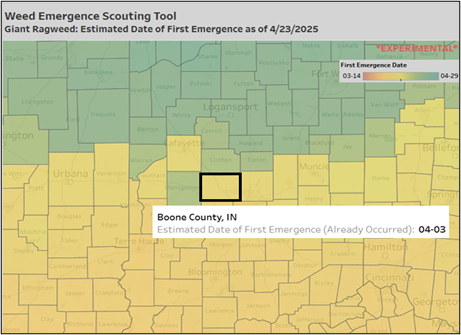
Midwestern farmers have faced a buildup of pesticide resistance in pigweeds (waterhemp and Palmer amaranth), highlighting the importance of scouting to detect weeds early in their growth stages.
Midwestern farmers have faced a buildup of pesticide resistance in pigweeds (waterhemp and Palmer amaranth), highlighting the importance of scouting to detect weeds early in their growth stages.
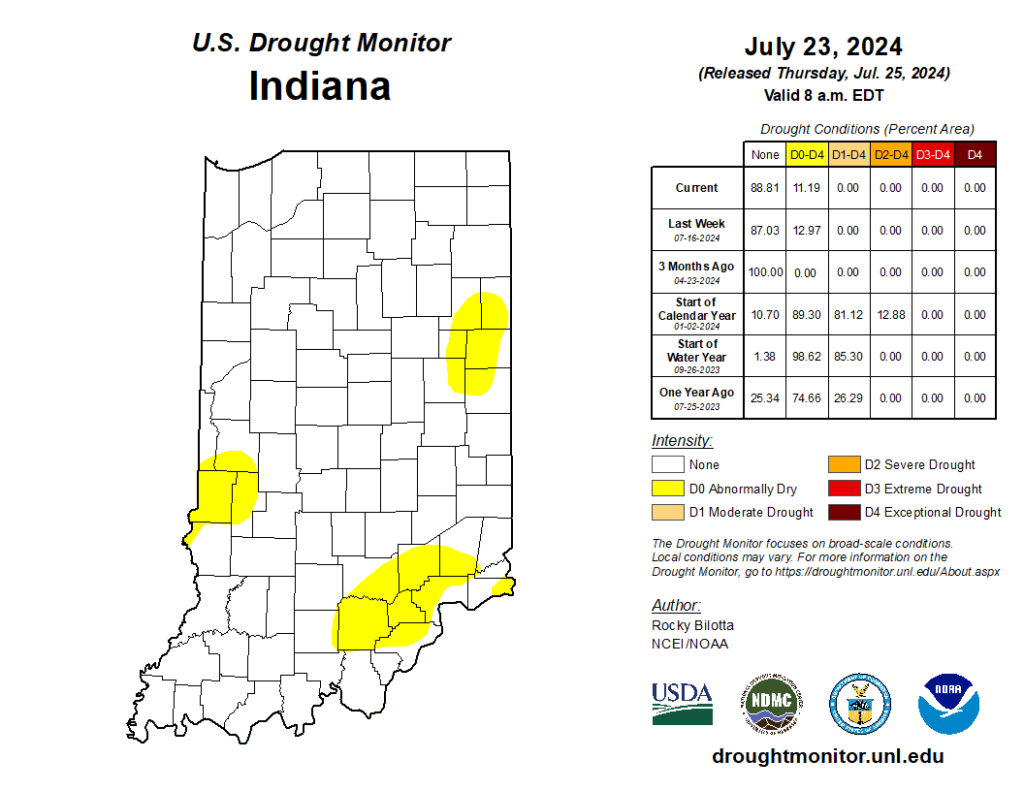
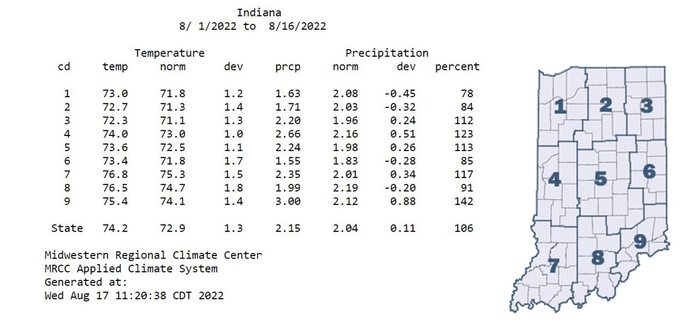
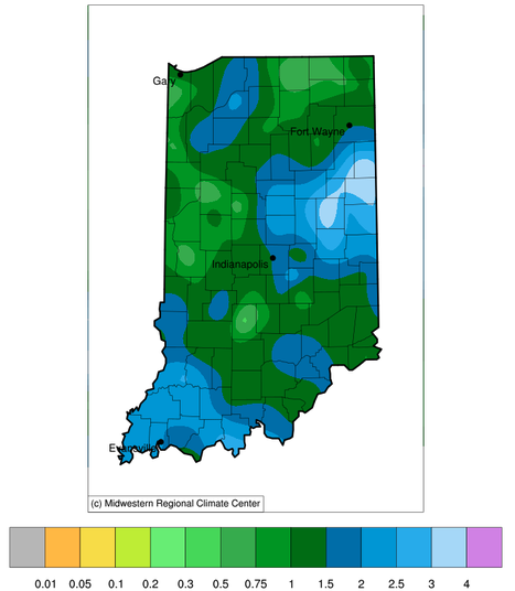
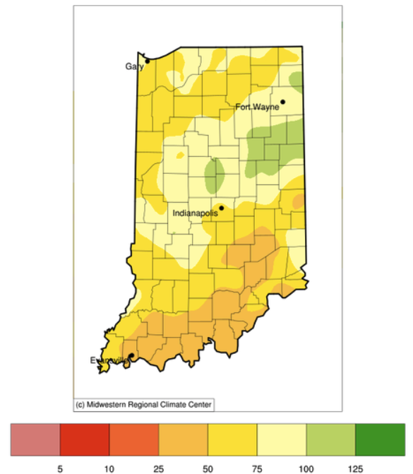
Several weeks ago, Indiana received enough rain to eliminate drought across the state, leaving behind just a few counties in Abnormally Dry (D0) status. Fortunately, this week has been relatively quiet, allowing many areas to alleviate flooding issues. The U.S. Drought Monitor kept those Abnormally Dry areas nearly the same this week (Figure 1), so how might things change? Will this recent dry period re-introduce Moderate Drought (D1) and/or expand those Abnormally Dry areas? Or will more rain keep Indiana in a more normal situation where precipitation passes through every few days, separated by typical Midwest hot and humid conditions? First, it is important to review what has been happening across our state. Over the past two weeks, Figure 2 shows that most of Indiana has receive above-normal precipitation except for southeastern and southern Indiana. However, even those locations are within one inch of normal amounts (based on the 1991-2020[Read More…]
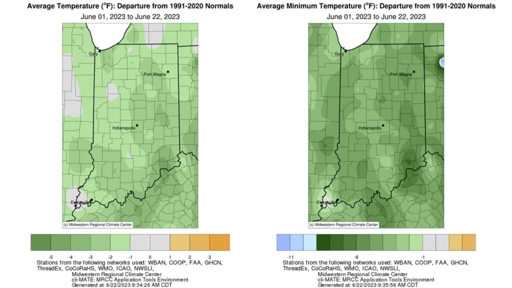
Below-normal temperatures continued through the first 21 days of June as the state average temperature was 68.3°F, which was 1.8°F below the 1991-2020 climatological normal. Temperature departures were 1-5°F below normal across the state, with larger departures in eastern and southern Indiana (Figure 1, Left). Maximum temperatures were near normal for the entire state, and minimum temperatures ran 1-9°F below normal (Figure 1, Right). Dry air and limited overnight cloud cover are to blame. Several locations measured minimum temperatures in the 40s at some point this month, but Franklin County recorded a chilly 36°F on June 9th. This station also tied with Shelby County for the second highest temperature recorded so far this month, 95°F, which occurred on June 3. Dubois County hit 97°F on June 4th. There were more than 20 daily low temperature records broken or tied during the second week of June. Over the last week, maximum[Read More…]
Temperatures warmed into the 80s by the end of Memorial Day weekend, but low dew point temperatures made the heat bearable.

After another wet weekend and cooler temperatures to start this week, it may be surprising to hear that conditions will be changing back to warm and dry for the next several weeks.
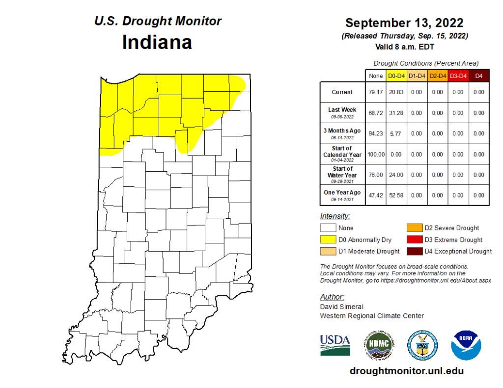
After another wet weekend and cooler temperatures to start this week, it may be surprising to hear that conditions will be changing back to warm and dry for the next several weeks. Climate models are strongly favoring above-normal temperature throughout the rest of September with a slight favoring of below-normal precipitation. Abnormally dry conditions continue to persist in counties across northern Indiana, but the spatial extent is gradually shrinking (Figure 1). It is too soon to tell if the upcoming warm and dry outlooks will be strong enough to expand and intensify those drier areas or if a few periodic rain events will be enough to keep conditions relatively stable. Monthly (October) and seasonal (September-October-November) outlooks were released on 15 September 2022. For both of these time frames, the outlooks are favoring above-normal temperatures to continue with below-normal precipitation across Indiana (Figure 2). With each day that passes, we get[Read More…]
Cooler weather has arrived as all of the Indiana climate divisions average temperatures were 1-1.8◦F above normal, compared to the 4-6◦F above normal temperature departures from a week ago.
This past weekend brought some much-needed rain to the Hoosier state.
The June 2022 state average precipitation was 2.42 inches below the 1991-2020 normal, which ended up being the 14th driest on record.
Indiana has been receiving less precipitation than normal, particularly over the last 30 days (Figure 1).
© 2026 Purdue University | An equal access/equal opportunity university | Copyright Complaints | Maintained by Pest&Crop newsletter
If you have trouble accessing this page because of a disability, please contact Pest&Crop newsletter at luck@purdue.edu.
