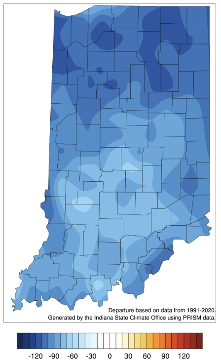
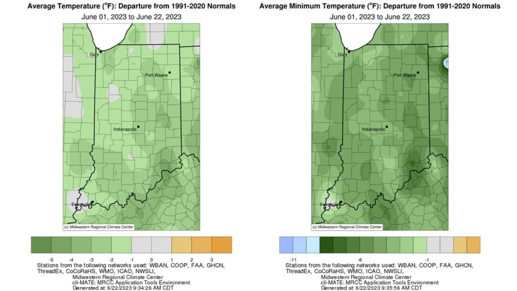
Temperatures warmed into the 80s by the end of Memorial Day weekend, but low dew point temperatures made the heat bearable.
A break from the heat has commenced as average temperatures dropped to 2-6◦F below normal this week.
Indiana has been receiving less precipitation than normal, particularly over the last 30 days (Figure 1).
Last week was marked by cooler temperatures and lots of rain.
Enjoy these cooler, drier September days while you can. Climate outlooks from the national Climate Prediction Center are strongly favoring above-normal temperatures for the 6-to-10-day period of September 14th through 18th. Precipitation outlooks are slightly favoring above-normal conditions, but will then shift to drier-than-normal conditions. This should mean fewer muggy days with lower heat index values. The average September temperatures across Indiana – based upon the 1991-2020 period – range in the 60s with daytime highs between 75°F and 80°F. Therefore, even if the climate outlook holds true, above-normal temperatures in September should be more tolerable than in July or August. Modified growing degree-day (MGDD) accumulations since April 1 currently range from slightly above around 2500 units in northern Indiana to slightly over 3200 units in southern Indiana (Figure 1). This is around 80 to 140 units above normal in the northern part of the state and 50-100 units below[Read More…]
After several weeks of above-normal precipitation across much of Indiana, we are now entering a relative dry period. The national Climate Prediction Center is indicating enhanced chances for below-normal precipitation amounts over the next several weeks. Temperatures are also expected to be above normal over this period which will cause increased rates of evapotranspiration. This may induce the onset and establishment of a flash drought – defined as a rapid intensification of drought conditions and impacts sustained for a relatively short amount of time (e.g., less than a year). The key is to start planning and preparing for this now, even if a flash drought does not end up developing, so that one is being proactive rather than reactive to drought impacts. Modified growing degree days range from about 1500 units (northern Indiana) to 200 units (southern Indiana) (Figure 1). With temperatures being relatively mild lately, this has kept accumulated[Read More…]
Current temperatures and rainfall report.
Abnormally dry/drought conditions continue across most of Indiana.
Rain moved across Indiana earlier this week, bringing much-needed precipitation to the northern counties.
Two weekends ago, Indiana was facing freezing temperatures that broke numerous records across the state.
© 2023 Purdue University | An equal access/equal opportunity university | Copyright Complaints | Maintained by Pest&Crop newsletter
If you have trouble accessing this page because of a disability, please contact Pest&Crop newsletter at luck@purdue.edu.