

Last week was marked by cooler temperatures and lots of rain. Field days were limited and flowers were waiting to be planted. Then came this week. Temperatures are reaching the upper 80s to low 90s with dew point temperatures over 70F (anything over 60F or 65F starts to really feel muggy). The statewide rain spigot has turned off with only intermittent rain possibilities until this weekend when the chance for more rain and thunderstorms will increase across the state. What happened? Did we blink and miss spring? It can certainly feel that way, but alas, these swings back and forth between extreme conditions seem to be our new norm.
The good news is Indiana has made it past any reasonable climatological risk of a hard freeze still occurring. Severe weather has spared Indiana so far this season, and a brief period of warm dry weather could be welcomed! However, it would be a problem if the state did not receive any more significant rain for an extended period and temperatures stayed high. The current climate outlooks are favoring above-normal temperatures, but there is too much uncertainty among the climate models to provide guidance on whether precipitation over the next several weeks to months will be above or below normal. Seasonal drought outlooks (through the end of July) are suggesting our region will be spared any major drought developing, though brief periods of dryness are always possible.
La Niña is continuing to linger in the equatorial Pacific Ocean. Forecast models are favoring this La Niña to gradually weaken but not fully transition to the neutral phase until later this summer or early fall. Climatologically, La Niña events in the summer have been associated with much warmer-than-normal temperatures and precipitation amounts that are near or slightly below normal across Indiana. La Niña events have also been associated with fewer tornadoes but a higher frequency of hail events. This is still severe weather season, so the risk continues to have severe weather.
Modified growing degree-day accumulations have been lagging the climatological average for this time of year (Figures 1 and 2), however this week’s heat event may help them catchup.
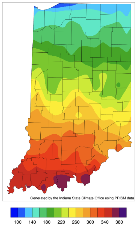
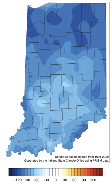
Figure 2. Modified growing degree day (50°F / 86°F) accumulation from April 1-May 10, 2022.
