

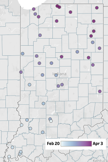
Temperatures dipped below freezing earlier this week as spring perennials started forcing their way out of their winter slumber.

Temperatures dipped below freezing earlier this week as spring perennials started forcing their way out of their winter slumber.
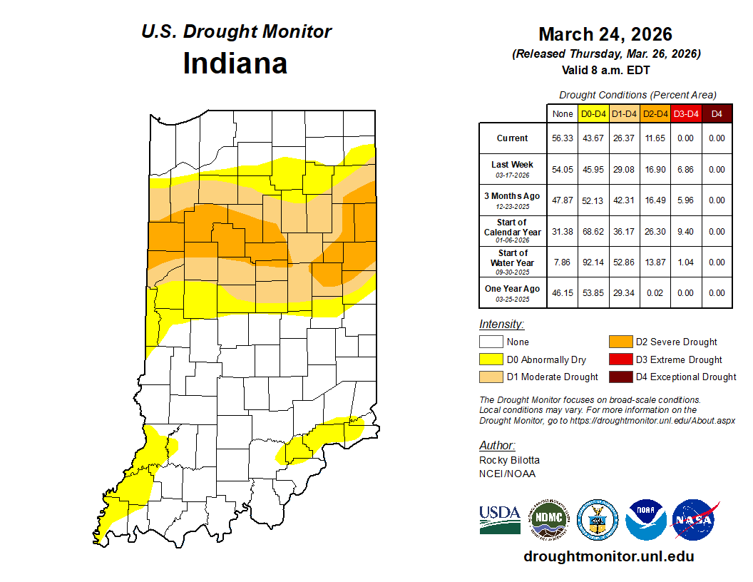
Indiana has exceeded its previous maximum duration record of 46 weeks in drought (since May 20, 2025) since the U.S. Drought Monitor (USDM) began in 2000.
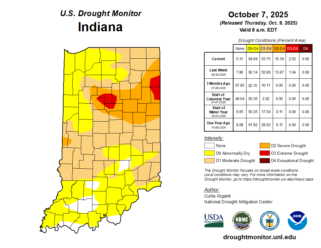
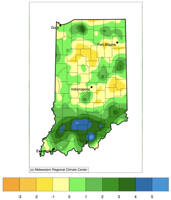
Prior to the rain event October 6-7, 2025, most of Indiana had only received between 0.5” – 2.5” of precipitation over the past 30 days.

The last week has caused many to struggle with whether to turn the heat on inside.
The last week has caused many to struggle with whether to turn the heat on inside. Mornings have been quite chilly, and I am guessing several readers may have also struggled with the decision to wear a jacket as they started their workday. These are tough decisions, no doubt. Several data sources have suggested we have had at least 2 weeks of consecutive below-average daily mean temperatures. While not a record, this is certainly noticeable! Perhaps we are hoping those tomato plants will produce just a few more tomatoes. Is it mum season, already? The good news – for those not quite ready to say goodbye to warm days, not needing coats, and garden delights – is warm temperatures are expected to return. Daily high temperatures are already in the 80s and Indiana is likely to see temperatures in the mid-90s by next week. There is significant confidence that this[Read More…]
Hot, muggy days in Indiana can get old, quickly! With all the rain lately, and higher humidity, it has been a challenge to get any nighttime relief.
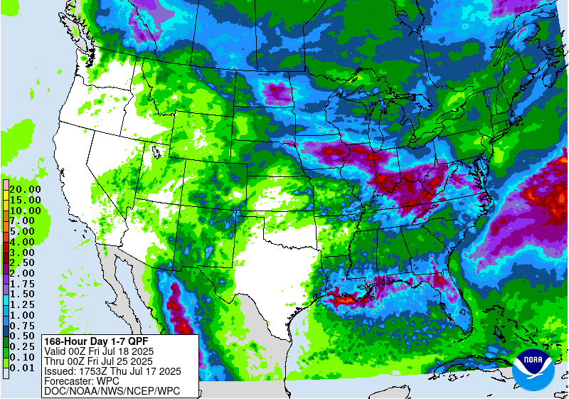
Precipitation forecasts for Indiana over the next 7 days (through late Thursday, July 24) are calling for close to 3 inches (Figure 1).

One heat wave down, more to come.
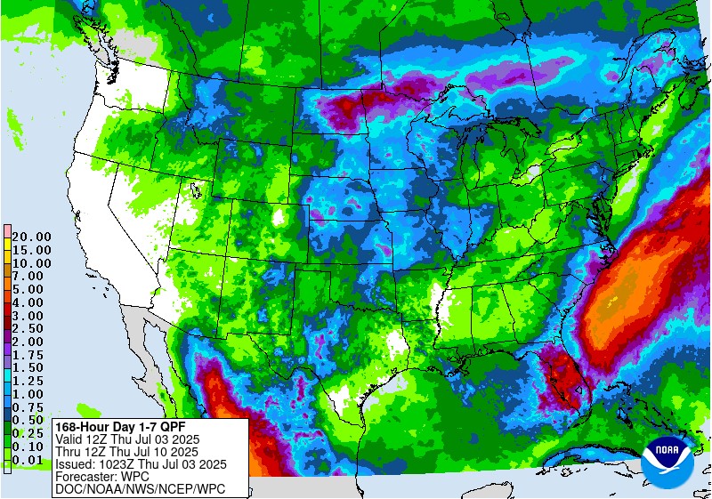
One heat wave down, more to come. It is summer, though, so aside from expecting plenty of hot days, the things to be more concerned about is reference (or potential) evapotranspiration (ET) significantly exceeding precipitation that would ultimately cause drought-related impacts. The National Weather Service provides a 7-day forecasted reference ET product as well as a 7-day forecast for total precipitation amounts. From these resources, it looks like across Indiana, approximately 1.5” of water is expected to be lost over the next 7 days and anywhere from 0.10” to up to 1.5” of precipitation will be received (Figure 1). This implies a water deficit for most areas – which is not unusual throughout Indiana summers. The concern comes when that deficit becomes much greater than normal. Concerning drought, the U.S. Drought Monitor continues to place northwestern Indiana in the Abnormally Dry (D0) category with two isolated areas within that zone[Read More…]

June 20, 2025, marks the summer solstice in the northern hemisphere. This is more an astronomical (i.e., planetary and orbital, not necessarily huge) event rather than meteorological. This is the date when the north pole is leaning most directly toward the sun due to its tilt relative to earth’s solar orbit throughout the year. Because of this, the length of daylight within a 24-hour period is greatest on this day for all locations north of the equator. More daily daylight means more solar exposure and therefore greater surface heating and temperatures. Of course, we’ve been working up to this moment for a while (since December 21, 2024) and we’ve already been experiencing warmer temperatures. Mother Nature is going to really show off her solstice spirit, however, with extreme high temperatures expected by the end of this weekend into next week. Over the last 30 days or so, average temperatures across[Read More…]
© 2026 Purdue University | An equal access/equal opportunity university | Copyright Complaints | Maintained by Pest&Crop newsletter
If you have trouble accessing this page because of a disability, please contact Pest&Crop newsletter at luck@purdue.edu.
