

There is the common adage “April showers bring May flowers”. Apparently, Mother Nature utilized a rather liberal definition of “showers” last weekend and the end of last week by dumping over seven inches of rain in southern Indiana. This has pushed the 30-day percent of normal across most of the state over 200 percent – or double what is climatological normal for that period (Figure 1).
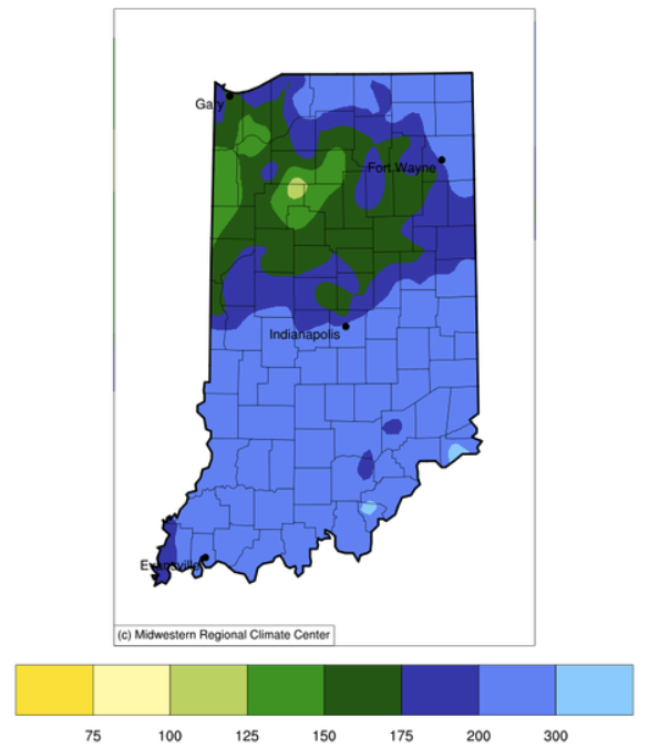
Figure 1. Precipitation presented as the percentage of normal for the period March 11 through April 9, 2025.
One might think this would mean all of Indiana would be void of any drought or even areas classified as ‘Abnormally Dry (D0)’. But alas, that is not the case for several reasons. Figures 2 and 3 show the U.S. Drought Monitor map based on data through April 1st and April 8th, respectively. While all the Abnormally Dry (D0) areas from the April 1st map has been removed for April 8th, the area that was previously labeled Moderate Drought (D1) is now Abnormally Dry (D0). Why not remove everything? First, the 90-day precipitation amounts compared to normal are still slightly below normal in the current Abnormally Dry (D0) area. Granted, a 90-day period is considering conditions from a while back in time but could still cause impacts in the broader scope of water management and planning. The other reason is that the classification of Abnormally Dry (D0) is often used as a transition indicator, suggesting conditions are either progressing toward drought or away from drought. Therefore, given the copious amount of rain recently experienced across the state, one can certainly argue that where there was Moderate Drought (D1) previously, conditions are improving.
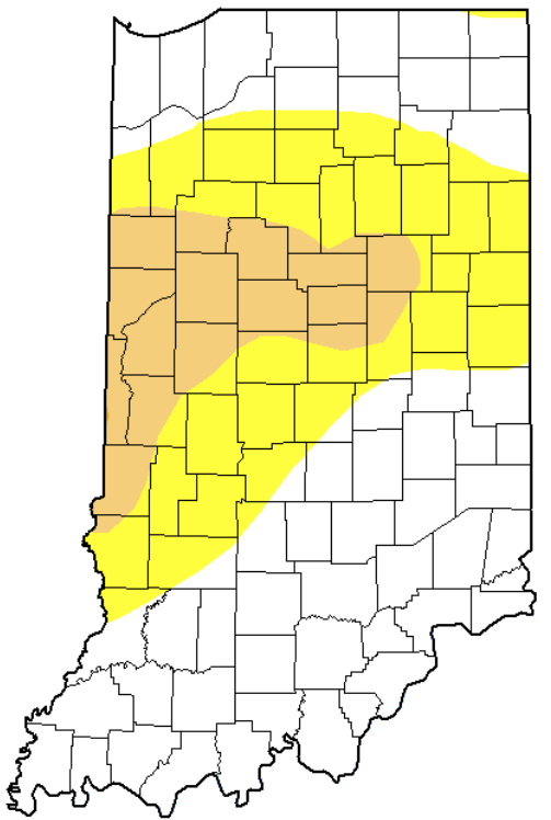
Figure 2. U.S. Drought Monitor representing conditions through April 1, 2025. Yellow indicates conditions are Abnormally Dry (D0); brown indicates conditions are in Moderate Drought (D1).
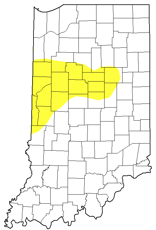
Figure 3. U.S. Drought Monitor representing conditions through April 8, 2025. Yellow indicates conditions are Abnormally Dry (D0); brown indicates conditions are in Moderate Drought (D1).
Looking ahead, the 7-day precipitation totals are expected to be less than half an inch across the state with the higher range more likely in the southern counties. Beyond 7 days out to April 23rd, temperatures a favored to be cooler than normal with slight probabilities of precipitation being above normal. There is a slight risk of an extreme cold event throughout most of Indiana (except for far northern counties) April 17-18 and a slight risk of heavy precipitation in southwestern counties April 17-19.
