

Prior to the rain event October 6-7, 2025, most of Indiana had only received between 0.5” – 2.5” of precipitation over the past 30 days. Relatively isolated regions in northwestern (La Porte and Starke counties) and central (e.g., Johnson, Shelby, and Hancock counties) Indiana as well as southern counties have received 3” – 4” in that period. To put this in historical perspective, Indiana has received 1” – 3” less rain that normal for the past 30 days. There was some hope that the rain event this past week would help alleviate some of the drought concerns that have been developing. Unfortunately, aside from an area from around the Monroe-Lawrence County line northeastward through Union County (that received over 3” in some places), most of the state received less than an inch of precipitation with the winners being those along the Ohio River and the greater Chicagoland area. Areas in north-central and western Indiana received no precipitation. As a result, most of Indiana continues to be at least Abnormally Dry (D0) as dry as Severe Drought (D3) status (see Figure 1).
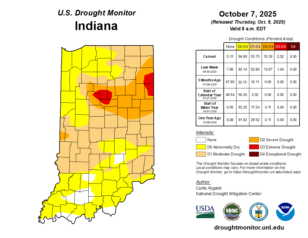
Figure 1. U.S. Drought Monitor status for conditions as of Tuesday, October 7, 2025.
Temperatures continue to be above normal over the past 30 days by almost 8 degrees F. It has been hard to believe it is October with those temperatures! After the rain event passed through, however, temperatures have dropped, and humidity has lowered allowing for near freezing overnight temperature. Several low-lying areas may have recently experienced some frost. Never fear, though. Climate outlooks for October 14-22 are favoring above-normal temperatures to return and stick around a while. The average Indiana maximum temperatures (based upon 1991-2020 data) range from 60°F – 70°F during that period, so hopefully no triple digits headed our way! Average minimum temperatures are typically in the 40s. However, the average date of the first 32° freeze is around mid-October for most of Indiana. Therefore, any freeze event we might see will not be that unusual. For more detail on freeze date climatologies, particularly for various temperature thresholds, check out the Midwestern Regional Climate Center’s Freeze Date Tool.
Growing degree-day accumulations since April 15 are wrapping up the season 150-300 units above normal. Given that total accumulations are now in the 3000-3800 range, this departure is relatively small, but still a testament to the warmer days throughout the growing season.
