Over the past several weeks, temperatures across Indiana have averaged within the normal range for this time of year. We may recall periods of extreme heat, but there were also periods that felt cooler with fall-like temperatures. Daytime maximum temperatures have averaged near normal whereas nighttime minimum temperatures have averaged slightly below normal. This has offered welcomed relief not only for livestock, pets, and humans, but has provide some much needed nighttime moisture recovery for vegetation, particularly as precipitation events have been few and far between.
Abnormally dry and moderate drought conditions have gradually been expanding and intensifying almost everywhere (Figure 1). The only locations that have been mostly spared – or more likely, still benefiting for recent storm tracks – is from west-central Indiana into central Indiana (Benton and Warren counties toward Madison County). However, even those counties are starting to show stress and could soon be classified as Abnormally Dry (D0) in the U.S. Drought Monitor if significant rain does not come soon. Elsewhere across the state, the drying tend has been relatively continuous and gradual except for southwestern Indiana. For those counties, the combination of no precipitation, a dry atmosphere, and very warm temperatures has set up a situation of rapid drought intensification — or what some may call a “flash drought”.
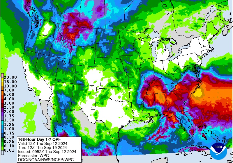
Forecasters are keeping an eye on what computer models are predicting regarding tropical storm Francine that has been developing in the Gulf of Mexico. Current models are favoring a path that will take the remnants of this storm northward toward Indiana. If this happens, southwestern Indiana is likely to benefit the most, but with only around a few inches (Figure 2). There rest of the state is likely to be too far from the storm track to get much precipitation. However, so many factors could influence amounts, location, intensity, and timing. At this time, there are doubts that this event will be a “drought buster” for Indiana, but it will certainly be welcome wherever it occurs to keep water supplies strong and vegetation without too much stress.
Beyond this weekend, climate outlooks over the next few weeks are strongly favoring above-normal temperatures and near-to-below-normal precipitation. Average high temperatures for this time of year are typically in the mid- to upper-70s (F), so expect highs to be in the 80s (F) if not teasing the low 90s (F) range. Average accumulated precipitation (1991-2020) has typically favored higher amounts (2-2.5 inches) in southern Indiana with 1-1.5 inches in the northern half of the state. Therefore, climate models are predicting similar or less amounts this year over the next few weeks.


