There was a period earlier this year when southern Indiana was getting all the rain. Flooding was a concern. The rest of Indiana was hoping for their share.
Then this week happened.
A lot of rain has fallen almost everywhere but southern Indiana. Perhaps this will provide some time for those down south to assess if things have returned to normal, or if there are now visible indicators of abnormally dry or even moderate drought developing. There is still some rain (not a lot) expected in these regions so hopefully that will keep either moisture extreme (drought or flooding) from happening.
Then, there’s the rest of Indiana. Locations in eastern Indiana have reported over 6 inches of rain within 24 hours! Over the past few days, amounts across northern and eastern Indiana have totaled from 3” to almost 10” (Figure 1). There are several locations (e.g., Delaware County) that reported over 17 inches in just 48 hours! Severe storms, including strong winds and possible tornadoes, have also been plaguing many of these areas. It may be a while before a full inventory of damage and impacts will be realized. We sincerely hope everyone is doing okay.
With such a spatial disparity across Indiana, the U.S. Drought Monitor (USDM) has removed an Abnormally Dry (D0) area in northeastern Indiana but has introduced a few smaller areas in south-central Indiana (Figure 2). This map is based on conditions prior to 8 AM Eastern Time this past Tuesday, so even those areas may be removed when next week’s USDM map is released.
Looking ahead, the 7-day accumulated precipitation (through the morning of August 20th) shows a lot of rain still to come. Heaviest total amounts are expected from northwestern Indiana down toward the greater Cincinnati region. Figure 3 illustrates how southwestern Indiana is likely to see the least amount over the period. Every day over the next week is expected to have rain falling somewhere across out state with the most active days being near the end of this week and the end of next week. The 6-to-14-day climate outlooks (August 18-26) is favoring above-normal temperatures. Above-normal precipitation is slightly favored in the earlier part of the period with near-normal amounts expected in the latter half.

Figure 1. Total precipitation amount from the morning of August 10-13, 2026, reported by CoCoRaHS observers.
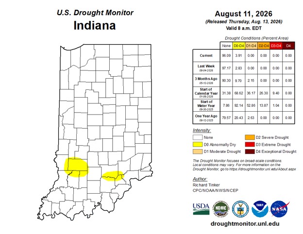
Figure 2. U.S. Drought Monitor status for conditions through early Tuesday morning (August 11, 2026).
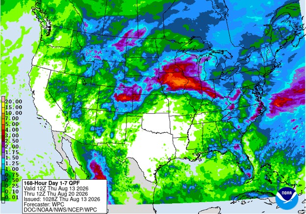
Figure 3. Seven-day precipitation accumulations through the early morning of Thursday, August 20th.