

The weather has been absolutely beautiful over the past few days. Temperatures have finally rebounded, vegetation is green again, and agricultural crops are beginning to emerge from the freshly planted fields. Despite the warming temperatures, we still have not dug ourselves out of the below-normal start to May. Through the first ten days of the month, Indiana averaged 0.7◦F below normal (Figure 1). The largest departures occurred in climate divisions 6 and 9, which were 1.6◦F and 1.9◦F below normal, respectively. Angola, located in Steuben County, was the coldest location with an average temperature of 50.9◦F (4.0◦F below normal). Evansville was the warmest with an average temperature of 63.4◦F, which was 2.0◦F below normal. Accumulated Modified Growing Degree Days (April 1 – May 10) continued to run within 60 MGDDs of normal throughout the state (Figure 2). Statewide, MGDDs have accumulated between 160 and 420 units since April 1.
Four-inch soil temperature showed diurnal swings, but temperatures have trended upward since May 4. At 9:30 AM EDT on May 11, all Purdue Mesonet station four-inch temperatures were above 55◦F (Figure 3, left). Time series for the Pinney and Davis Purdue Agricultural Centers show that the four-inch soil temperatures are fluctuating more than 10◦F each day as low air temperatures drop into the low to mid 50s (Figure 3, right). Four-inch soil temperatures have not been below 50◦F since May 4.
Through the first ten days of May, precipitation totals have been highly variable as a result of the recent convective storms. Statewide, though, precipitation ran slightly above normal (103 percent of normal). Climate divisions 2, 3, and 4 all received more than 120 percent of normal precipitation (Figure 1). Over the last 30 days (April 12-May 11), the heaviest precipitation was measured in southwestern, central and northeastern Indiana (Figure 4, left). Totals were 25-75 percent of normal across most of the state (Figure 4, right). The May 9 US Drought Monitor had abnormal dryness (D0) in a couple of locations in the state that include portions of Vermillion, Warren, Fountain counties and Lake, Porter, Jasper, LaPorte, and Starke counties (Figure 5).
For the forecast, temperatures look to remain warm through this weekend. Scattered, convective precipitation is also expected with clearing conditions by mid-week. The Weather Prediction Center’s precipitation forecast indicates rain totals between 0.25-1.25 inches over the next seven days (Figure 6). Longer-range models are hinting at low temperatures in the upper 30s and low 40s next weekend, followed by a rebound to more seasonable temperatures. A light frost may not be out of the question. The Climate Prediction Center’s temperature and precipitation outlooks expect higher chances for below-normal temperatures and below-normal precipitation over the next fourteen days (Figure 7 and Figure 8).
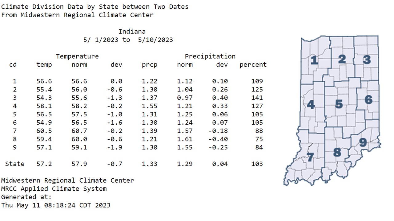
Figure 1: Indiana climate division and state temperature, normal temperature, temperature departure from normal, precipitation, normal precipitation, precipitation departure from normal, and percent of mean precipitation for May 1-10, 2023.

Figure 2: Total Accumulated Indiana Modified Growing Degree Days (MGDDs) April 1-May 10, 2023 (left) and Total Accumulated MGDDs represented as the departure from the 1991-2020 climatological normal (right).
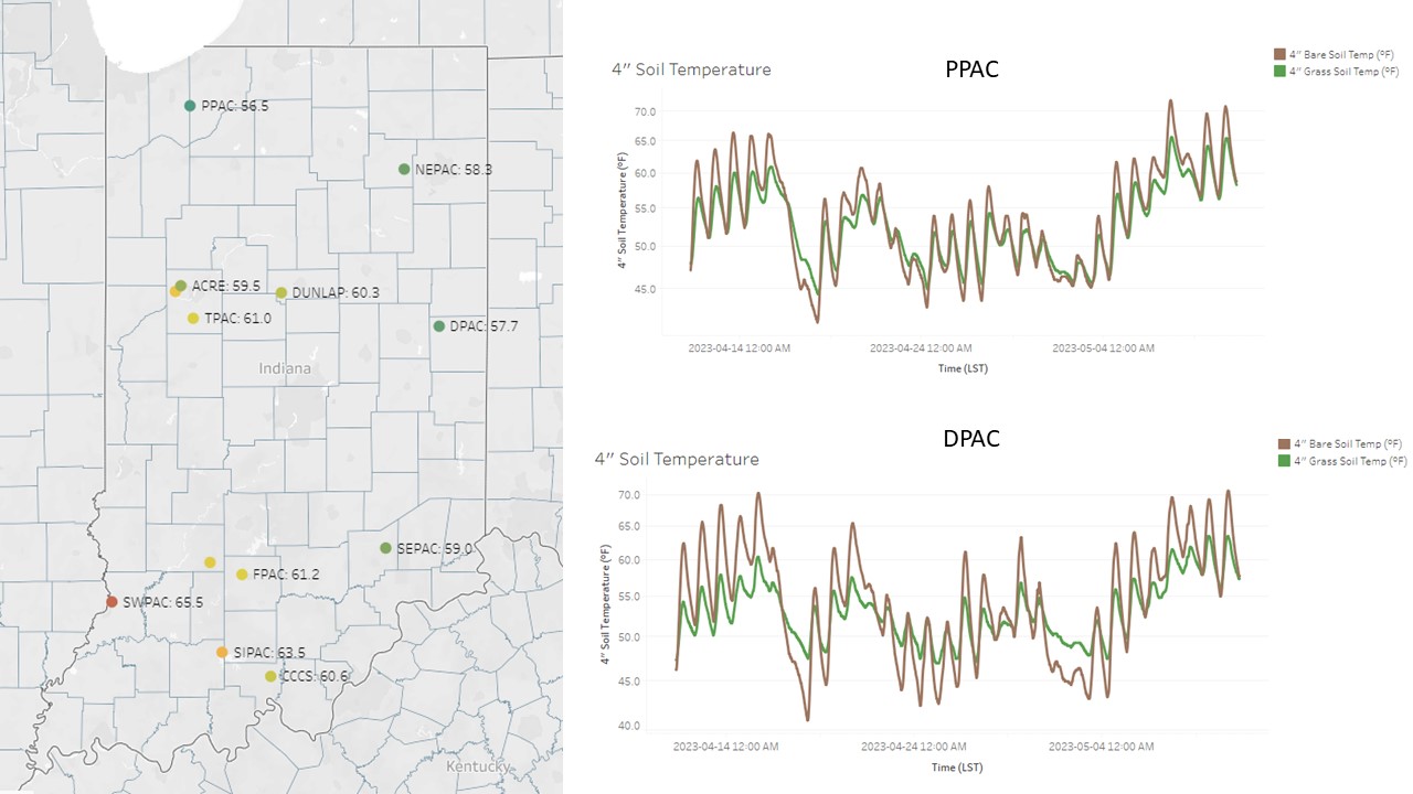
Figure 3: Four-inch soil temperatures at 9:30 AM EDT, May 11, 2023 (left) and four-inch (right) soil temperature graphs for Pinney Purdue Agricultural Center (PPAC) and Davis Purdue Agricultural Center (DPAC), which can be found on the Purdue Mesonet Data Hub.
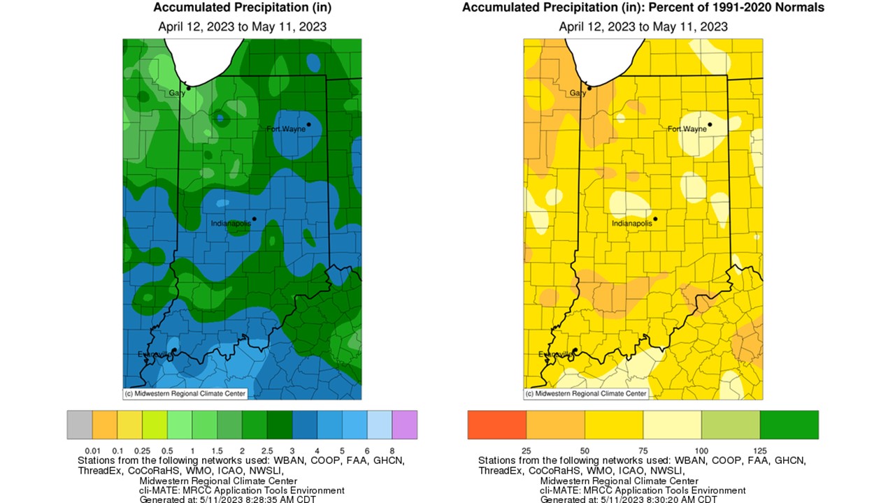
Figure 4: Interpolated map displaying accumulated precipitation for April 12-May 11, 2023 (left). Interpolated map displaying accumulated precipitation as a percent of the 1991-2020 climatological normal (right).
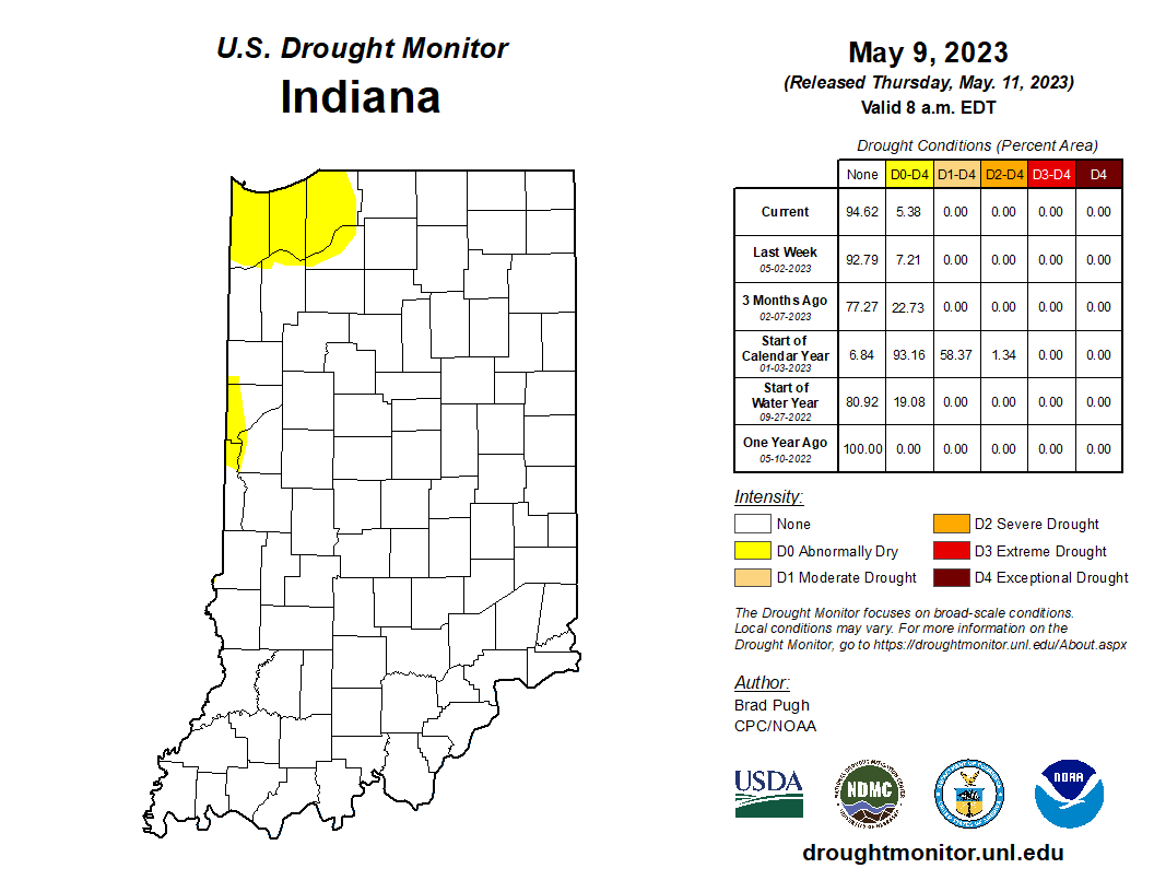
Figure 5: May 9, 2023, US Drought Monitor. The US Drought Monitor is released every Thursday morning by 8:30 AM.
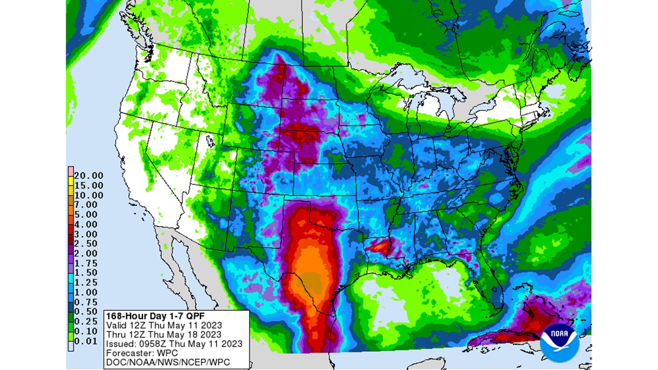
Figure 6: NWS Weather Prediction Center 7-day quantitative precipitation forecast for the continental United States, valid May 11-May 18, 2023.
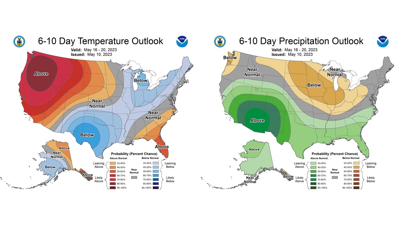
Figure 7: The CPC’s 6–10-day temperature and precipitation outlooks, valid for May 16-20, 2023.
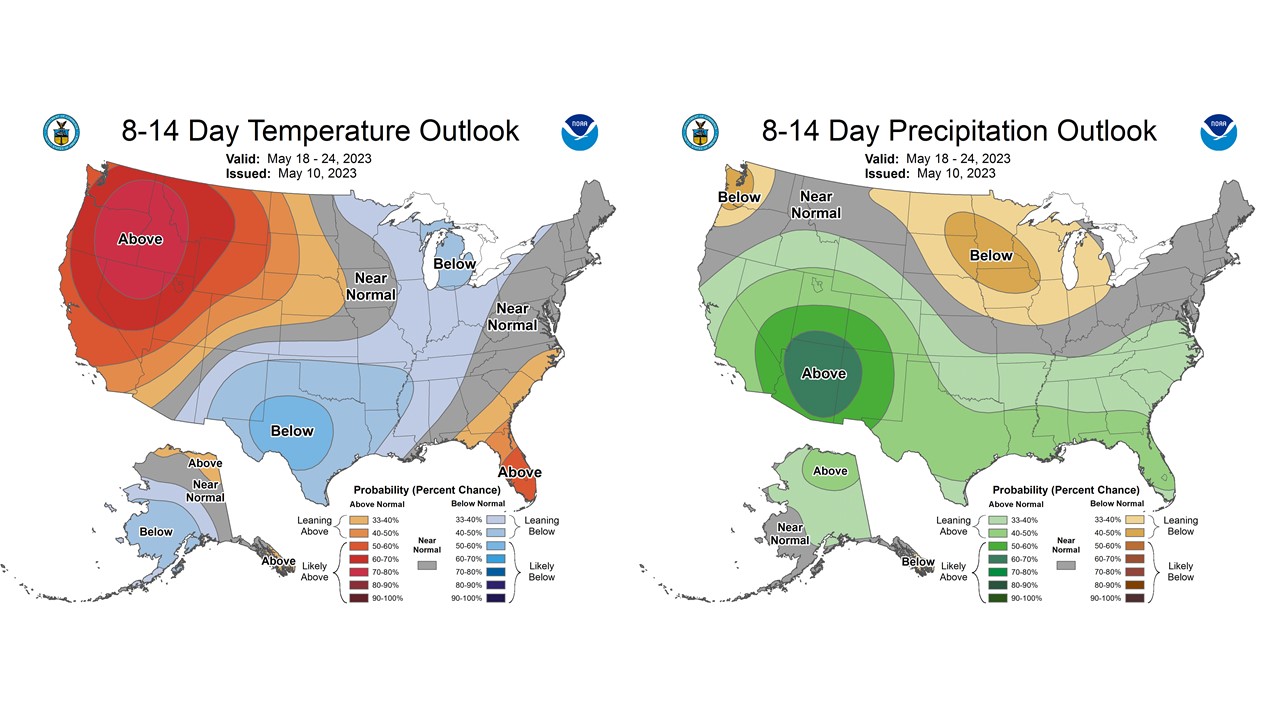
Figure 8: The CPC’s 8-14-day temperature and precipitation outlooks, valid for May 18-24, 2023.
