Indiana has had its fair share of very cold temperatures this winter. In January, wind chills were teasing the -20°F mark across much of the state, which is becoming increasingly rare due to global warming. This is a good reminder that “global warming” is just that – “global” and not local. Locations elsewhere on our planet were still above normal; Indiana just happened to be in one of those isolated pockets where below-normal temperatures were hanging around. February (so far) has been slightly warmer, but as of February 25th, the average daily temperature has still been 1 to 3 degrees below normal. Last week was likely the significant contributor to those below-normal average temperatures for the month.
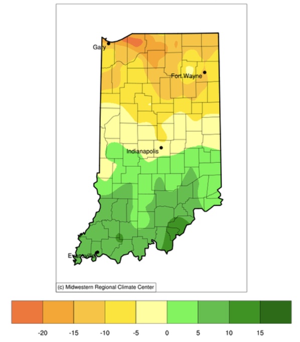
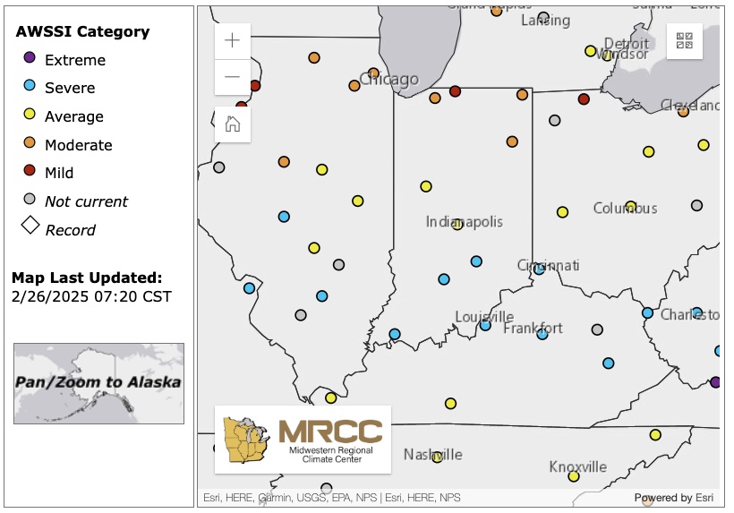
Regarding snowfall, southern Indiana has received up to 10 inches above-normal amounts, while northern Indiana has received up to 20 inches below normal (Figure 1)! This has been quite unusual since northern Indiana tends to receive much more snowfall than southern counties. Since December 1, 2024, the snowfall totals across the state have been relatively even with amounts ranging mostly between 10 and 20 inches. If we combine how snowy and how cold this winter has been so far, how might it compare historically? The Midwestern Regional Climate Center provides the Accumulated Winter Season Severity Index (AWSSI [pronounced like “Aussie”]; https://mrcc.purdue.edu/research/awssi). According to this tool, this winter (so far) has been “Severe” for southern Indiana and “Moderate” to “Mild” in northern Indiana (Figure 2).

Figure 1. Snowfall departure (in inches) from the 1991-2020 normal period for December 1, 2024 through February 25, 2025.
Will things start improving? According to Punxsutawney Phil (our fearless, yet often incorrect, prognosticating groundhog), we should expect six more weeks of winter (since February 2nd). Of course, astronomically, he’s spot on, since there were six more weeks until the spring equinox. I’m never quite sure how to assess if he is correct from the social perspective. Would this mean those six weeks will be colder than normal? Snowier than normal?
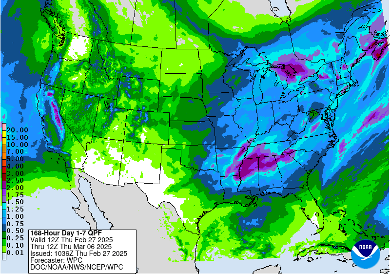
From a more scientific perspective, temperatures over the next 7 days are expected to be near normal with maximum temperatures ranging from the mid 30s°F in northern counties up to the low 50s°F in the southern counties. Precipitation is expected to be most active around the middle of next week with amounts between 0.75 to 1.5 inches (Figure 3). Climate outlooks over the 6-to-14-day period (through March 11th) are slightly favoring above-normal temperature with above-normal precipitation in the early part of that period and near-normal precipitation amounts near the end. Beyond that, both the March as well as the March-April-May climate outlooks are strongly favoring above-normal precipitation with strongest confidence over the Indiana-Michigan-Ohio region. There is no indication about whether temperatures will be above or below normal for these periods. While this could suggest another wet spring that may bring challenges to row crop planting, the climate models are seeming to be heavily influenced by the La Niña that’s been lingering in our tropical Pacific Ocean. If that dissipates, then the climate outlooks may transition away from these patterns and perhaps this coming spring will not be as wet as the climate models are predicting.
In the meantime, enjoy these more spring-like conditions but know chances are still high for at least one more freezing temperature weather system to pass through our area!


