

Indiana has exceeded its previous maximum duration record of 46 weeks in drought (since May 20, 2025) since the U.S. Drought Monitor (USDM) began in 2000. The previous record was 44 consecutive weeks. This was a bit of a surprise when I saw this, since this includes the drought of 2012 and multiple other drought periods in recent years. Forty-four weeks (the previous record) isn’t even a full year! As our statewide drought team meets weekly and conditions have been slowly improving in that northern band of dryness, most of this area had been missing out on the multiple rain events that locations south of I-70 have seen. Things seem to be turning around, though, where the D3 locations (defined by the USDM as “Extreme Drought”) have gradually improved to D2 (“Severe Drought”; see Figure 1) and perhaps next week those D2 areas can improve even further to D1 (“Moderate Drought”).
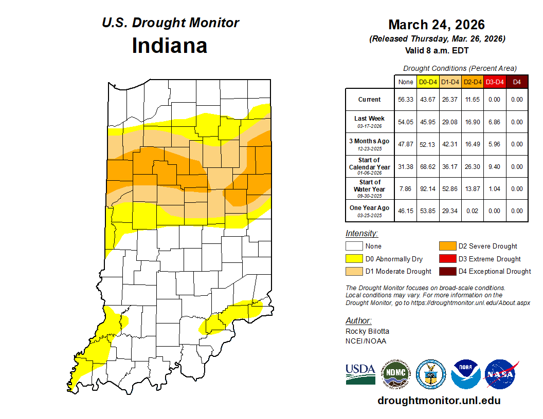
Figure 1. U.S. Drought Monitor status for conditions as of Tuesday, March 24, 2026.
Determining which level of drought, abnormal dryness, or even no drought to recommend to the national USDM author has been a weekly challenge. Regarding shorter-termed drought such as meteorological and agricultural, there are very few areas in drought across Indiana. These types of droughts are driven by recent precipitation amounts compared to climatology and how wet the soils are. However, the longer-term types of drought (e.g., hydrological) have been struggling to recover. Streams and rivers in some locations have not been staying at normal levels in locations where the USDM is indicating drought (albeit, they flow well for a brief time after significant rain events) and groundwater levels have a long way to go before reaching levels that fall within the 30th to 70th percentile of historical values. That is quite significant, and can raise concerns for domestic water supplies, water that may be needed later in the growing season for irrigation, and water demands from developing industries. Therefore, as one looks at the USDM map for Indiana and sees areas that are classified as “abnormally dry” or worse while looking out the window at standing water in fields and gullies, think about how much of that is making its way down to our unseen groundwater supplies and over to our surface water sources!
Looking ahead, Indiana will continue to be in a rainy pattern where the 7-day forecast of total precipitation is predicting amount around 1 inch still to come (Figure 2). Beyond that, the 6-to-10-day outlook (April 7-15) is slightly favoring above-normal temperatures on the front end of that period and then strongly favoring above-normal temperatures near the end. Precipitation is predicted to be near normal to possibly above normal during that same period. The 3-month seasonal outlook (April-May-June) is slightly favoring above-normal temperatures with no guidance regarding precipitation. This may be due to sub-seasonal patterns that swing broadly from too much to too little precipitation with very little consistency in a particular direction.

Figure 2. Total precipitation amounts (in inches) predicted for April 2-9, 2026.
