Fall has brought cooler weather through the first twelve days of October. The entire state has run below normal with an average temperature of 55.6◦F, which was 1.3◦F below normal (Figure 1). Central and southern Indiana’s temperatures ranged from 1.4-2.3◦F below normal and northern Indiana was a little closer to normal with temperatures ranging from 0.4-0.8◦F below normal. Many areas in central and northern Indiana saw the first 32◦F temperature with frost, which was about a week earlier than the average first freeze date (Figure 2). Randolph County measured a low temperature of 27◦F on October 6 and almost a week later, Jasper County recorded a low temperature of 27◦F on October 11. These temperatures were about two to three weeks earlier than average. It was definitely cold enough to light the fire place! Modified Growing Degree Days were still above normal for most of central and southern Indiana (Figure 3), as most locations exceeded 3,000 MGDDs since April 15.
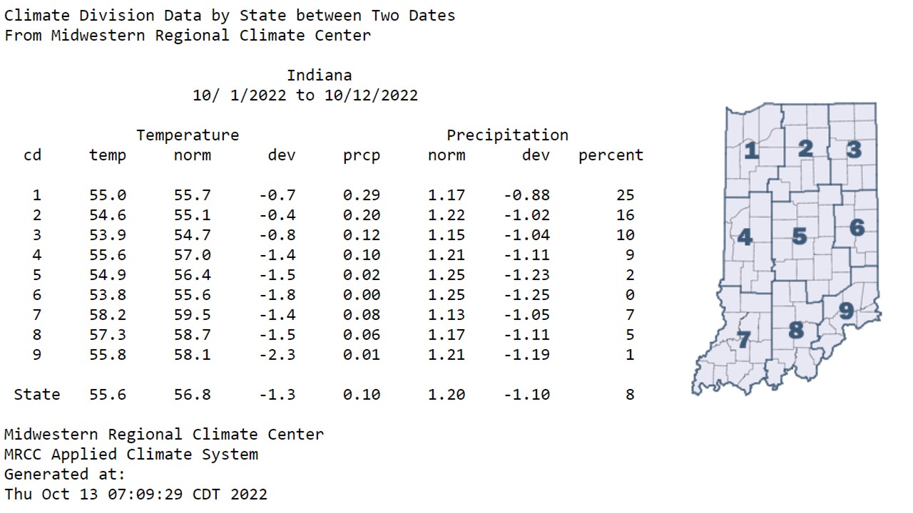
Figure 1: Indiana temperatures, normal temperatures, temperature deviations, precipitation, normal precipitation, precipitation deviations, and percent of normal precipitation by climate division for October 1-12, 2022.
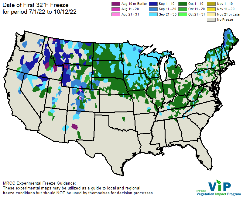
Figure 2: The Midwestern Regional Climate Center’s Vegetation Impact Program (VIP) map displaying the date of first 32◦F for the United States.
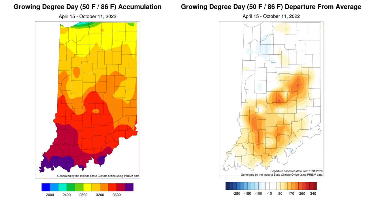
Figure 3: Left – Modified Growing Degree Day accumulations April 15-October 11, 2022. Right – Modified Growing Degree Day accumulations April 15-October 11, 2022, represented as the departure from the 1991-2020 climatological average.
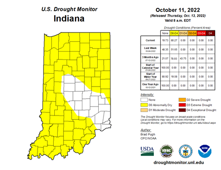
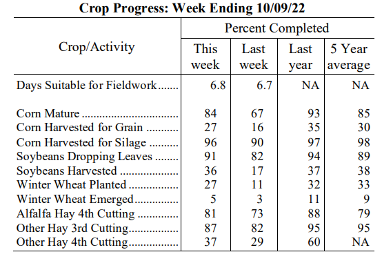
Precipitation has been ghosting us, literally… see what I did there? With all jokes aside, precipitation has been below normal so far in October. This is a trend that has continued since mid-September. The entire state averaged eight percent of normal rainfall or 1.10 inches below normal. Eastern Indiana, Climate Division 6, has received no precipitation through the first twelve days of the month. The October 11 US Drought Monitor has over 80 percent of the state in abnormally dry (D0) conditions (Figure 4). Red Flag Warnings have been issued for a large portion of the state, which means that the risk of wildfires is high. The primary factors contributing to this are the lack of rainfall, strong winds, and low relative humidity. The dry weather has helped harvest, but the NASS Crop Weather report indicated that the corn harvested for grain and soybeans harvested were slightly behind the five-year average (Figure 5). The dry weather certainly helps with harvest progress and should benefit from the forecasted dry conditions.
Most of the state does not have precipitation forecasted through October 20th, and the Climate Prediction Center outlooks highlight elevated chances for below-normal temperatures. These outlooks indicate higher chances for above-normal temperatures toward the latter part of the month. Dry conditions are expected to continue through the end of October.


