For the second week in a row, the much-appreciated cooler temperatures remained from August 17-23. The preliminary state average temperature was 71.2◦F, which was 1.2◦F below the 1991-2020 normal. The largest temperature departures were observed in central and southern Indiana, where departures were up to 2.1◦F below normal. After a warm, wet beginning to August, month-to-date temperatures (Figure 1) remained slightly above normal through August 23 (0.6◦F above normal). Daytime high temperatures in south-central and southern Indiana were cooler than normal (Figure 2, Left) while overnight lows were 1-3F warmer than normal (Figure 2, Right). From April 1-August 24, Modified Growing Degree Days continued to run 102 percent of normal for the state. Central and southern Indiana has the highest Modified Growing Degree Day departures (Figure 3).
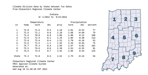
Figure 1. August 1-23, 2022 climate division and state average temperatures, normal temperatures, temperature deviations, average precipitation, normal precipitation, precipitation deviations, and percent of normal precipitation compared to the 1991-2020 climatological averages.
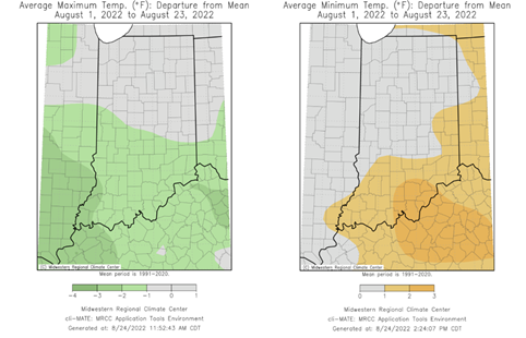
Figure 2. Left – Average maximum temperature in degrees Fahrenheit for August 1-23, 2022, represented as the departure from the 1991-2020 normal temperature during that period. Right – Average minimum temperature in degrees Fahrenheit for August 1-23, 2022, represented as the departure from the 1991-2020 normal temperature during that period.
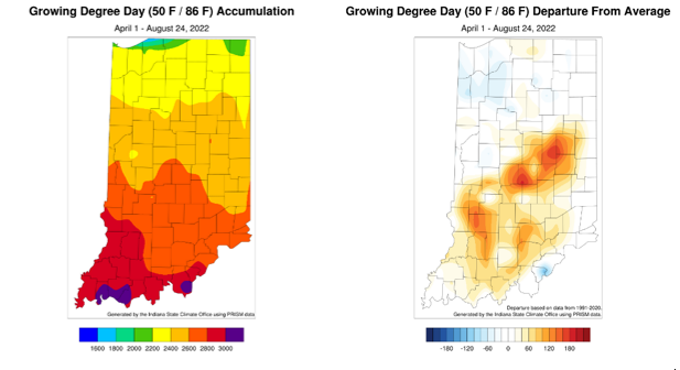
Figure 3. Left – Modified Growing Degree Day accumulations April 1-August 24, 2022. Right – Modified Growing Degree Day accumulations from April 1-August 24, 2022 represented as the departure from the 1991-2020 climatological average.
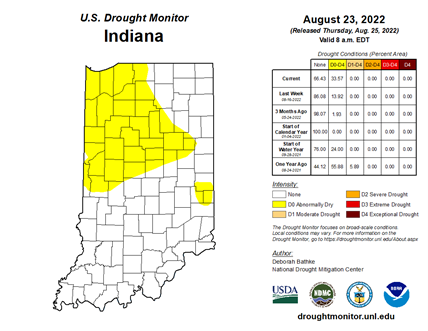
Dry conditions settled in for August 17-23 as the state average precipitation was 0.48 inches (0.27 inches below normal or 64 percent of normal). Central and southern Indiana were the driest regions, averaging less than 60 percent of normal rainfall for the week. Clay County, Indiana, recorded the highest precipitation with 1.94 inches falling on August 21. Several stations actually missed out on adequate precipitation during this period (Figure 4, Left) and received less than 50 percent of normal rainfall (Figure 4, Right). State preliminary precipitation has averaged 2.79 inches for August 1-23, which is 94 percent of normal. As of August 23, river and stream gauges in the northwestern and central part of the state had 7-day average streamflows that were ranked below the 25th percentile (Figure 5). The August 23rd US Drought Monitor brought expansion of the Abnormally Dry (D0) category through the northern part of the state, but Moderate Drought has not yet returned (Figure 6).
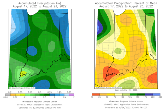
Figure 4. Left – Accumulated precipitation from August 17-23. Right – Accumulated precipitation from August 17-23, represented as the percent of the 1991-2020 normal precipitation that fell during this period.
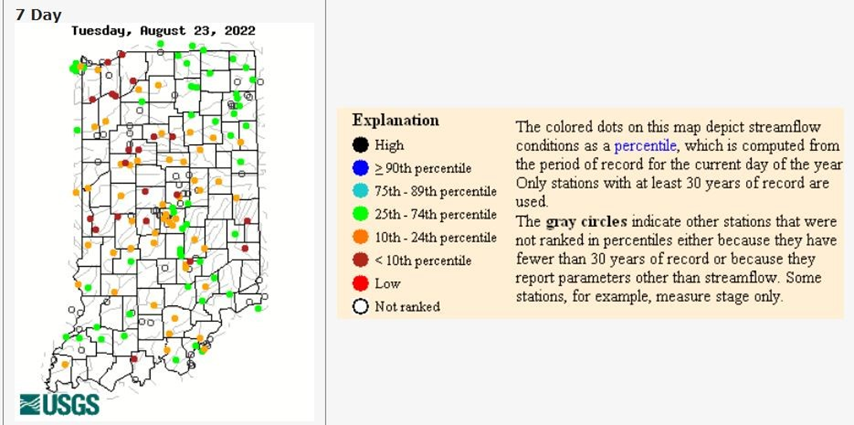
Figure 5. Seven-day average stream flows across Indiana as of Tuesday, August 23, 2022 using date from the USGS Water Watch.
The Climate Prediction Center outlooks have been accurate for August so far. The 6–10-day outlook for August 30th– September 3rd has higher confidence in above-normal temperatures statewide. Precipitation is expected to be below normal in the northern, normal in the middle, and above normal in the extreme southern parts of the state (Figure 7). The 8–14-day outlook (September 1-7) has elevated confidence in near-normal temperatures through much of the state with areas of higher confidence in above-normal temperatures in extreme northern Indiana. Precipitation is expected to be below normal throughout most of the state with near-normal precipitation in southern Indiana (Figure 8).
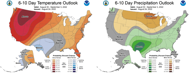
Figure 7. The Climate Prediction Center’s 6-10-day temperature (left) and precipitation (right) outlooks for August 31-September 3, 2022.
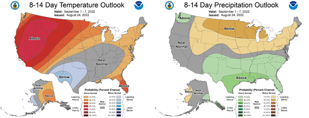
Figure 8. The Climate Prediction Center’s 8-14-day temperature (left) and precipitation (right) outlooks for September 1-September 7, 2022.


