Geo-positional inaccuracies in DGPS signals affect the accuracy of yield monitor data in various ways. Inaccurate DGPS signals can cause inaccurate automatic header width adjustments which, in turn, directly impact the accuracy of yield estimates themselves (Nielsen, 2020b). Another type of yield monitor error that is related to imprecise DGPS signal sources is one associated with the automatic hybrid labeling of yield data points during the harvest operation.
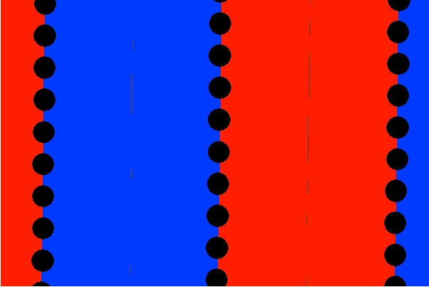
Some planter displays allow you to “track” what hybrids or varieties are being planted and record this information in a planting log for the field. If you are planting different hybrids in the two halves of the planter, the display can also log this spatial information in a coverage file during the planting operation (Fig. 1).
During harvest, the same display can use the logged planting information to automatically label yield data points with the appropriate hybrid identification by matching the combine’s geo-position in the field during harvest with the logged geo-position of the planted hybrids. This capability to automatically “tag” yield data points with the identity of the planted hybrids enables you to easily summarize average yields by hybrid either on the display itself or later in your mapping software.
The Wandering Hybrid Syndrome
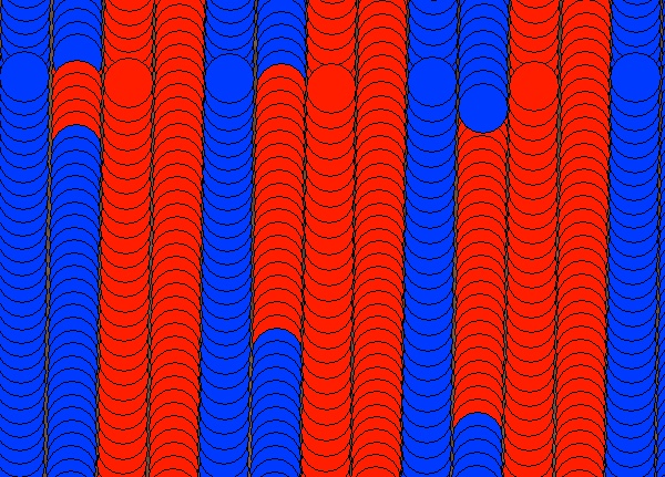
Inaccuracies in perceived geo-position can result in inaccurate hybrid labeling of yield data points during harvest. Figure 2 illustrates several harvest passes in a field that were planted with a 16-row planter that had different hybrids in the two 8-row halves of the planter and were harvested with an 8-row combine. Sections of three harvest passes of 8 rows of Hybrid B (blue) were mislabeled as being Hybrid A (red).
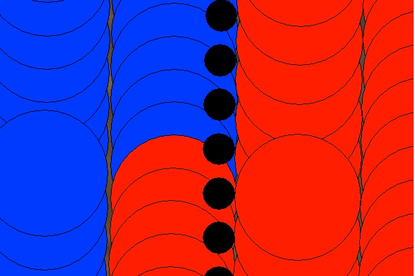
The DGPS signal source for the planting operation was RTK (1-inch accuracy) and that used for the harvest operation was WAAS (5 to 15-ft accuracy), which resulted in the occasional imprecise overlapping of logged planting and harvest passes in the field. In some areas of the field, the positional error in the overlapping of the planting and harvesting passes was great enough that it resulted in inaccurately labeled harvest data points.
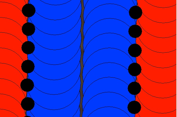
Figure 3 illustrates an area of the field where the geo-positions of the two field operations overlapped precisely. The black data points represent the logged geo-position of the center of the 16-row planter (aka the planting coverage file). The red (Hybrid A) and blue (Hybrid B) yield data points represent the logged center of the 8-row combine, but also correspond to the center of each half of the planter when positioned correctly relative to the logged data points of the planting coverage file.
Figure 4 illustrates an area of the field where the geo-positions of the two field operations do not overlap precisely. The yield monitor occasionally senses (incorrectly) that the path of the combine has drifted far enough into the other hybrid’s logged geo-position that it incorrectly labels those yield data points as being the other hybrid.
In contrast to auto swath width errors where the cause is only related to pass-to-pass geo-positional inaccuracies during the harvest operation itself, errors in automatic hybrid labeling may be compounded if geo-position inaccuracies occur during both planting and harvesting. The most likely scenario for this would be if WAAS (5 to 15-ft accuracy) were used as the DGPS signal source for both planting and harvesting.
Consequences of Wandering Hybrid Syndrome?
Recognize that the consequence of inadvertently erroneous hybrid labels on the accuracy of yield estimates per se is…. nothing. That is because, contrary to incorrect swath widths, hybrid labels have nothing to do with the yield monitor’s estimation of yield for each data point.
The primary consequence of inadvertent erroneous hybrid labeling of yield data points is that it leads to mistakes “down the road” if those hybrid labels are then used to filter and analyze the yield data. Several scenarios can be considered and the probability of each is unpredictable.
Let’s consider two hybrids, A and B, with different yields. Let’s say that the actual average yield for Hybrid A is 200 bu/ac and that of Hybrid B is 180 bu/ac.
- If some proportion of Hybrid A’s data points (200 bu potential) are mislabeled as Hybrid B, but none of Hybrid B’s data points (180 bu potential) are mislabeled, then the apparent yield of Hybrid B will be inflated.
- The consequence would be reversed if some percentage of Hybrid B’s are mislabeled as Hybrid A but none of Hybrid A’s are mislabeled.
- If equal proportions of Hybrid A’s and Hybrid B’s data point are mislabeled, then there may be no consequence later summaries of the yield data by hybrid.
So, how can you tell whether your yield data is afflicted with Wandering Hybrid Syndrome?
- If you use auto-steer on your combine, I suppose you could keep your eyes glued to the display monitor and watch the hybrid names change as you harvest the field :-).
- Some, but not all, mapping software programs allow you to visually display the logged yield data by their assigned hybrid names. That allows you to visualize the hybrid name changes throughout the field as illustrated in Fig. 2.
- Unfortunately, this diagnostic occurs after the “cows have broken through the fence” and only points you in the right direction for future harvesting.
So, what can be done to prevent or minimize the occurrence of Wandering Hybrid Syndrome?
- Equip both your planter tractor and combine with precise DGPS signal sources, such as RTK, so that the both field operations log geo-position precisely (within inches) and repeatably.
So, what can be done once the problem has occurred and you are stuck with a bunch of yield files containing incorrect hybrid attributes?
- Some mapping software programs allow you to highlight / select groups of data points and then edit their “properties” or “attributes”. For small areas of fields where the data mapped by “hybrid” indicates mistakes in hybrid assignment, you could then edit and correct the hybrid names. For large and/or numerous areas of fields with incorrect hybrid name assignments to the yield data, you may simply choose to “live” with the mistakes.
“We made too many wrong mistakes.” — Yogi Berra
Related reading
Luck, Joe and John Fulton. 2014. Best Management Practices for Collecting Accurate Yield Data and Avoiding Errors During Harvest. Univ. of Nebraska Extension publication EC2004. https://extensionpublications.unl.edu/assets/pdf/ec2004.pdf [URL accessed Oct 2020].
Nielsen, R.L. (Bob) Nielsen. 2020a. Identify and Eliminate “Gremlins” From Yield Monitor Data. Corny News Network, Purdue Extension. http://www.kingcorn.org/news/timeless/CleaningYieldData.html [URL accessed Oct 2020].
Nielsen, RL (Bob). 2020b. Wandering Swath Width Syndrome: Yield Monitor Errors. Corny News Network, Purdue Extension. http://www.kingcorn.org/news/timeless/AutoHeaderWidth.html [URL accessed Oct 2020].
Nielsen, RL (Bob). 2020c. Yield Monitor Calibration: Garbage In, Garbage Out. Corny News Network, Purdue Extension. http://www.kingcorn.org/news/timeless/YldMonCalibr.html [URL accessed Oct 2020].

Fig. 1. Example of logged planter data (black circles = planter center) and
the planter coverage file for a field planted with different hybrids in each
half of the planter (red = Hybrid A, blue = Hybrid B).

Fig. 2. Example of errors in automatically labeling yield data points with
previously logged hybrid information (red = Hybrid A, blue = Hybrid B).
NOTE: This view is “zoomed out” farther than that shown in Fig 1.

Fig. 3. Precisely overlapped geo-positions of logged 16-row planting
data (black = planter center) and 8-row harvest data (combine center),
resulting in accurate assignment of hybrids to yield data points
(red = Hybrid A, blue = Hybrid B).


