
USDA-NIFA Extension IPM Grant
Pest & Crop Newsletter, Entomology Extension, Purdue University
- Black Cutworm Arrival and Development, Timing is Everything
- Black Cutworm Development Map
- Alfalfa Weevil Development Map
- Black Cutworm Adult Pheromone Trap Report
- Armyworm Pheromone Trap Report
Black Cutworm Arrival and Development, Timing is Everything - (Christian Krupke and John Obermeyer)
- Black cutworm moths continue to arrive, some in big numbers.
- Past cool temperatures has suppressed larval devel-
opment. - Fields yet to be worked and planted are those of
greatest risk to black cutworm damage. - Seed/soil insecticides will provide suppression of
this pest, NOT control of heavy populations.
As already described in past Pest&Crop articles, storm fronts, with very high winds, over the last several weeks have blown large numbers of black cutworm moths into Indiana (refer to the “Black Cutworm Adult Pheromone Trap Report”). The timing of intensive moth captures, 9 or more moths caught over a 2-night period, and subsequent larval development may challenge corn yet to be planted.
Refer to the following “Black Cutworm Development Map,” where we are tracking black cutworm development from the time of multiple intensive captures to when we expect first cutting/damage. Based on the growth development model, it takes approximately 300 heat units (50?F base) from egg hatch to early 4th instar; this is the life stage when black cutworm larvae begin to cut plants. Some leaf injury may be present before then. Using pheromone trapping of moths and tracking of heat unit accumulations for first cutting is not an exact science, but they do give us a good indication of when to better time field scouting trips.
Because of the cool temperatures this spring, black cutworm larval development has been delayed. Meaning, the many acres of corn planted this week will likely “outpace” larval development. Of those fields yet to be worked and planted, the timing may coincide with larval development, thus threatening emerging corn. Tillage, at or just before, planting, will provide little control of the larvae feeding on weeds. Since black cutworm has been a minor pest the past years, producers may have a false sense of security with the seed-applied insecticides. Timely scouting and rescue foliar insecticides when necessary are the tried and true approach with this stand reducer. Happy scouting!
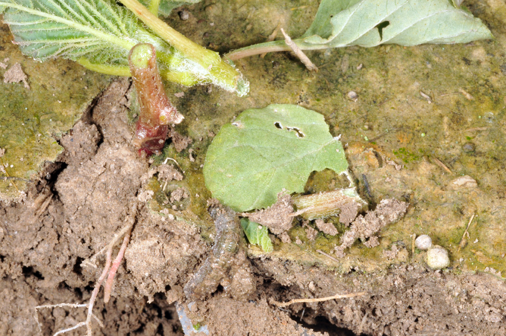
Natural weed control, pig weed destroyed by black cutworm larva
![]()

Bug Scout says: "AAny corn up in Southern Indiana counties should be scouted for leaf feeding!"
![]()
Bug Scout says: "Alfalfa weevil damage should be noticeable 2/3 up the state!"
![]()
Click here to see the Armyworm Pheromone Trap Report
![]()
Black Cutworm Adult Pheromone Trap Report
![]()
Weather Outlook by NOAA/NWS – (Jim Noel, NOAA/NWS/Ohio River Forecast Center) -
May began cooler and wetter than normal as expected. The week of May 5 started cool but then starting May 7 turned warmer than normal. Temperatures reach into the 70s and 80s for May 7/8. Outside of scattered light showers and a few thunderstorms, rainfall will be quite limited through May 8 which was good for ground work to resume.
As we reach May 9-12, rain chances will increase with a storm system yielding slightly above normal temperatures with above normal rainfall.
The week of May 12-18 will again see temperatures start slightly cooler than normal but should bounce back toward May 18 to above normal.
The climate theme for May remains unchanged as overall temperatures will swing back and forth between below to above normal with periods of rain. The month still looks to start cool and finish warmer than normal. Averaging it out temperatures for May should not be too far from normal.
Rainfall for May will be above normal though it appears with periods of dry and wet weather. The eastern corn and soybean belt should be wetter than normal for May while the western section normal or slightly drier than normal.
For the latest 16-day rainfall outlook for the corn, soybean and wheat belts from the National Weather Service Ohio River Forecast Center please visit: <http://www.erh.noaa.gov/ohrfc/HAS/images/NAEFS16day.pdf>.
This 16-day rainfall outlook is the mean of multiple weather model runs or consensus. Normal rainfall is 1.5 to 1.75 inches for this time period.
The 8-14 day temperature outlook can be found here: <http://www.cpc.ncep.noaa.gov/products/predictions/814day/814temp.new.gif>.
We continue to track the consensus historic years of winter/spring of 1962-63, 1978-79, and 1993-94. The result of those years was corn 6% above trend line, soybeans 3% above trend line and wheat at trend line yields for the eastern crop belt.
All indications are an El Nino may be forming in the Pacific Ocean. Based on years similar to Pacific Ocean water temperatures from this past winter to present and what is expected, the years closest to these include 1963, 1968, 1979, 1982, 1986 and 1997. The results for crop yields for corn were 5% above trend line, soybeans 6% above trend line and wheat 5% below trend line which are not much different than the best 3 analog years to this past winter. The bottom line is the climate patterns suggests decent yields this year but not as good as 2013 or as bad as 2012 but still likely above trend like except for wheat. Risk will begin to grow again and being below normal as expected in 2013 coming off record risk in 2011/2012. Risk in 2014 is considered about normal but increasing.

![]()